
Master Planning Process for the Arnold Rim Trail
The Arnold Rim Trail Association (ARTA) is initiating a master planning process for the Arnold Rim Trail. This master plan aims to address the future recreational needs and desires of the trail users and surrounding communities for years to come. As part of this process, ARTA is soliciting input from the community.
ARTA is excited to announce the opening of public input with the launch of an online survey. With the survey, ARTA is inviting all residents, visitors, and stakeholders to share their thoughts and suggestions on the future development of the trails.
View our Community Survey Results summary.
A Little History
In 2003, the Calaveras District Ranger for the Stanislaus National Forest issued a plan for the development of a “designed system of recreational opportunities in the “Interface” of the Calaveras Ranger District.”* That plan evolved out of a multi-year planning process that involved extensive public engagement among recreationists and the neighboring community. Aspiring to balance community input and resource conservation, the Forest Service laid out a plan that has guided improvements in the Interface for the past two decades. Those improvements included, among other things, an alignment and proposed construction of the Arnold Rim Trail. Under that plan, the Arnold Rim Trail was conceived as a non-motorized recreational trail open to hikers, cyclists and equestrians alike. With money from the federal infrastructure act of 2009 for “shovel-ready”** projects, much of the Arnold Rim Trail as we know it today was built. Today, the official Arnold Rim Trail extends more than 20 miles from the Logging Museum in White Pines to the south, connecting the communities of Arnold, Avery, and Hathaway Pines. In addition to the main route, several loops offer additional miles of curated trail opportunities for hikers, cyclists and equestrians. What remains to be built in order to complete the trail system designated in the approved Forest Service plan are two trail segments in San Domingo Canyon:
- An ½-mile segment that would enclose a ten-mile long, singletrack loop encircling San Domingo Canyon, and
- 1½-mile non-mechanized trail along San Domingo Creek showcasing a top destination identified during the planning process.
Originally, prior to the Calaveras District Ranger’s action in 2003, the Arnold Rim Trail was envisioned as a non-motorized, multi-use recreational trail that would circumnavigate the town of Arnold via a 35-mile loop that included connections to White Pines Park, White Pines Lake, and Calaveras Big Trees State Park. While only half of the original concept has been realized to date, the Forest Service’s 2003 plan for the Arnold Rim Trail has been substantially completed. As more than two decades have passed since Forest Service plan adoption, the time has come to reflect on our accomplishments and set a clear course for future recreational opportunities on the Arnold Rim Trail.
How Will We Do That? And What is a Master Plan?
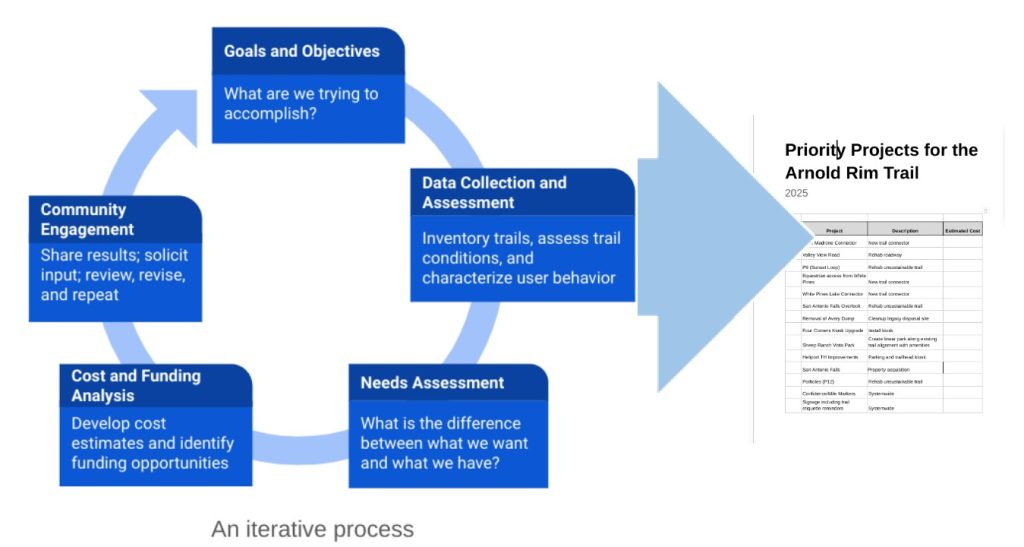
The purpose of the master plan is to serve as a blueprint for fulfilling ARTA’s mission. The plan will document a process that looks at existing conditions to understand current infrastructure and user behavior as needed to assess deficiencies and develop appropriate solutions. Working with trail users, local stakeholders and the neighboring community, a list of prioritized projects will be produced to serve as a guide for future efforts. Ultimately, the plan will not only address enhancements to the trail system, but also consider the community’s needs and interests for educational and outreach programs, and the requirements for a sustainable organization.
An iterative, community-driven process will be used to develop a master plan that will identify and rank a list of priority projects and guide the future of the Arnold Rim Trail.
The Bigger Picture
Timing of the Master Plan is Critical
Not coincidentally, several other planning efforts for non-motorized recreational trails are underway locally and are being undertaken by Calaveras County and the Stanislaus National Forest, as follows.
- Calaveras County Department of Parks and Recreation is currently developing a master plan for parks and recreation with a focus on County parks. See Calaveras County Parks Master Plan.
- Calaveras Council of Governments is currently developing an Active Transportation and Recreational Trail Plan whose scope is countywide. See Calaveras County Active Transportation and Recreational Trail Plan.
- Stanislaus National Forest is in the process of incorporating trail-related initiatives legislated by the National Forest System Trails Stewardship Act of 2016 into its policies and practices. Among other things, that Act called for the Forest Service to embrace shared stewardship as a path to a more sustainable and usable trails system.***
- Multi-agency programs for fuels management and watershed protection.
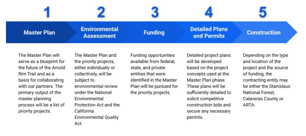
The Master Plan will provide timely, accurate and useful information for the National Forest to plan land access, recreational trails and community needs long into the future. To leverage our efforts and create synergies with our partners, it is critical that the master plan be completed in a timely manner to serve as input to our partners efforts. Collaboration with these agencies will result in a more cohesive and comprehensive approach to developing non-motorized recreational trails in our area while also improving our ability to secure funding for our priority projects.
Help the Arnold Rim Trail by Sharing Your Thoughts
From ARTA Chairperson: “The community’s voice is crucial in shaping the future of the Arnold Rim Trail. We encourage everyone who enjoys and values this incredible natural resource to participate in the survey and help us create a trail system that benefits all.”
Questions, Concerns or Comments? Contact us at info@arnoldrimtrail.org